
LLS 101 CAN PLUS

Government approved laser-guided land levelling system utilizes precision laser technology to optimize the grading of terrain, ensuring uniform surface elevation for agriculture purposes with increased efficiency and accuracy.

SELECT SYSTEM

LLS 101 5G 

Self-sufficient, effective, and long-range precise GNSS guided land levelling system. Standing up to date with the latest technology.

SELECT SYSTEM

Laser-matic

High-precision grading works are no problem with the MOBA leveling systems Laser-matic and Dual Laser-matic.

SELECT SYSTEM

AUTO STEERING SYSTEM

The Auto Steering System is a GNSS guided technology that automates the steering of farming vehicles, ensuring precise and efficient navigation, reducing operator fatigue, and optimizing field operations such as planting, harvesting and spraying.

SELECT SYSTEM

Challenges for agriculture


SUSTAINABILITY

Improving agricultural yields, conserving water, and preventing agricultural land degradation are three of the world 's most challenging priorities.

Creation Costs

Additional rework means more operational hours for your machine. This increases labour expenses and also inefficient, leading to decreased agricultural land productivity.

Creation Performance

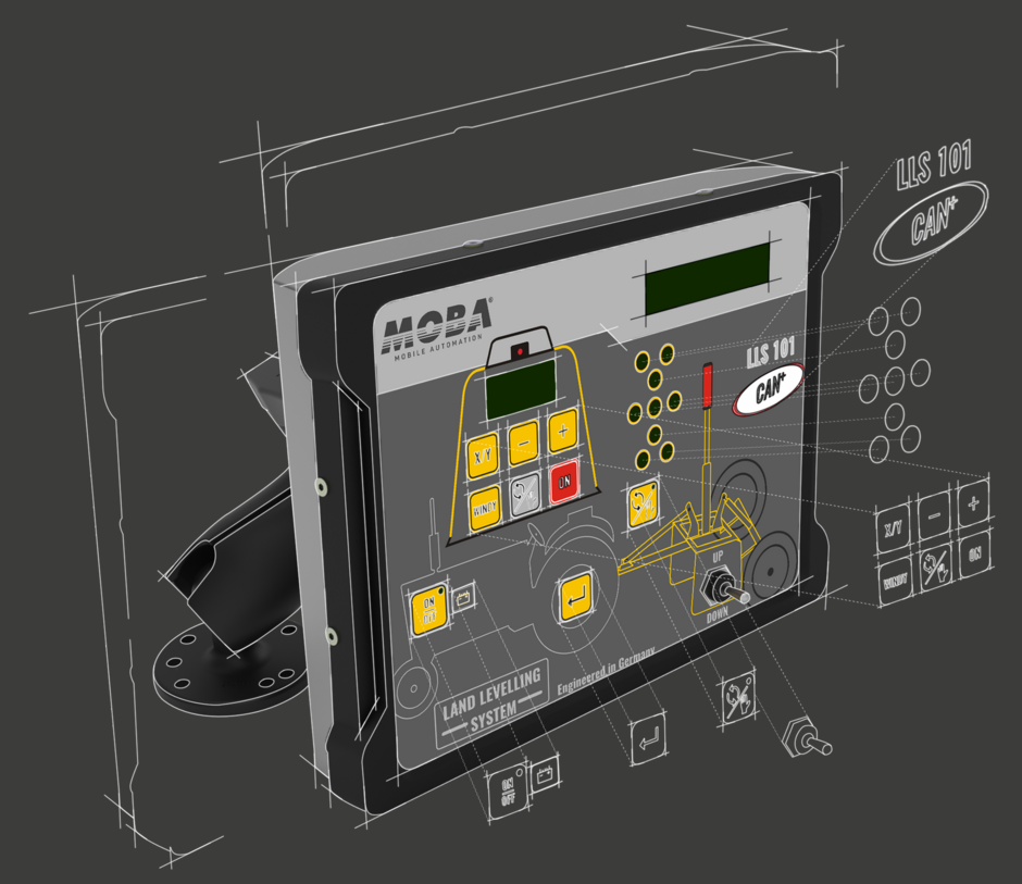
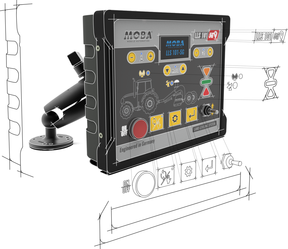
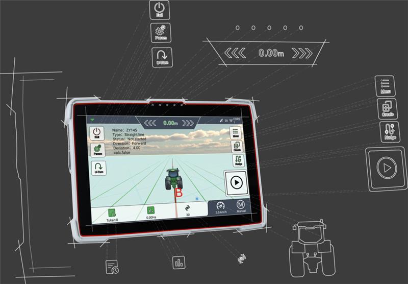
Without equipment, it is impossible to measure the exact slope and inclination during land leveling. Manual precision measurement and re-adjustment takes hours and an expensive process. However, if the measured parameters are incorrect, the results are unfavourable.

Solutions


01

ENSURE ACCURATE AND EFFICIENT LAND LEVELING WITH

MOBA LLS 101 CAN PLUS

Easy user interface specially designed for emerging markets, cost effective yet precise solution for agricultural land leveling. MOBA LLS 101 CAN Plus comes with an unique feature to operate transmitter from control box itself using RF technology. Fine grading of the field ensures improved water distribution, enhanced irrigation efficiency, and optimized crop productivity.

PerformanceSafetyAsistance

Your upgrade for Increased Agricultural Yield 

The laser-guided LLS-101 CAN PLUS System specifically designed to withstand robust weather conditions such as fog, wind, and high temperatures. It typically involves a laser transmitter that emits a laser beam across the field, and a receiver mounted on the bucket scraper detects the laser beam's elevation and communicates with the equipment's hydraulic system to automically adjust the blade to achieve the desired level of the land. This technology ensures accurate and efficient land leveling, improving water distribution, enhancing irrigation efficiency, and optimizing crop productivity in agricultural fields. 

Easy to operate

the robust design, intuitive buttons, displays, and visual LED assistance helps the operator to run land leveling system carefree.

LASER AS REFERENCE

denotes the use of a laser beam as a precise benchmark for elevation control, guiding the land leveling equipment to achieve uniform and accurate grading.

LLS 101 CAN PLUS COMPONENTS

  • BUCKET SCRAPPER

    BUCKET SCRAPPER

    Contract Manufactured heavy-duty Moba bucket scraper that cuts, moves, and distributes soil based on laser-guided elevation measurements to achieve precise land leveling.

  • CONTROL BOX

    CONTROL BOX

    The control box coordinates communication between the laser transmitter, receiver, and solenoid valve on the bucket scraper, processing real-time data to adjust the bucket’s blade or Scraper height, ensuring precise land leveling according to set parameters.

  • RECEIVER

    RECEIVER

    The receiver detects the laser beam emitted by the transmitter, measuring the distance between the beam and the land surface to provide real-time feedback to the control system, guiding the bucket’s blade or scraper’s height adjustments for precise leveling.

  • TRANSMITTER

    TRANSMITTER

    The transmitter emits a laser beam at a predetermined elevation, serving as a reference plane for desired land leveling, enabling the receiver and control system to adjust the bucket’s blade or Scraper height accordingly to achieve precise grading.

02

PERFECT SOLUTION FOR LONG RANGE LAND LEVELING

MOBA LLS 101 5G 

Latest Global Navigation Satellite System based technology for effective and precise leveling. Accuracy won't be affected by heavy wind or foggy weather conditions. An ideal choice for larger farms with easy set-up and low maintenance.

Performance

Designed for large agricultural land

MOBA LLS 101 5G, the fifth generation of land leveling system is an ideal choice for the long range and effective land leveling. it involves the use of Satellite navigation signals, such as GPS, to guide land-leveling equipment, ensuring optimal field topography for irrigation and crop management. The GNSS System provides real-time positioning data, allowing for efficient and automated adjustments to the land leveling equipement to create a uniform and level surface. 

bedienung_white_web

EASY USER INTERFACE

"Designed for simplicity", the GNSS guided land leveling system is easy to use, offering farmers intituitive controls and streamlined processes for precise and efficient leveling .

sensorauswahl_white

GNSS as reference

The GNSS antenna serves as the receiver for signals from GNSS systems mounted on the bucket scraper, the antenna captures the satellite signals, enabling precise and real-time positioning information, this data is then used to guide the equipment.

LLS 101 5G GPS LEVELING SYSTEM components

  • BUCKET SCRAPPER

    BUCKET SCRAPPER

    Mast-free bucket scraper equipped with satellite-based Land Leveling System, offering precise and maintenance-free land levelling.

  • GNSS CONTROL BOX

    GNSS CONTROL BOX

    The LLS 101 5G control box serves as the central interface, interpreting and processing positioning data from the GNSS antenna, enabling the operator to monitor and adjust the land leveling equipment in real-time.

  • BASE STATION

    BASE STATION

    The base station acts as a reference point, providing correction signals to enhance the accuracy of positioning data received by the GNSS antenna on the bucket scraper. 

  • GNSS antenna

    GNSS antenna

    Multi-frequency GNSS antenna is designed to receive signals from multiple satellite constellations on different frequency bands, enhancing the accuracy and reliability of positioning data.

03

Laser land LEVELING FOR MORE PROFIT

MOBA LASER-MATIC & DUAL LASER-MATIC

High-precision laser land levelling work is a vital part of today’s construction site requirements. A flat, even surface determines the quality of the overall project. The MOBA Laser-matic and Dual Laser-matic leveling systems solve this problem by upgrading your leveling blade and assisting the driver in his work.

Performance

Your upgrade for more Profit

The height or inclination of the dozer blade is shown on the intuitive display at all times. The system then automatically carries out the even levelling after setting the target value. This not only allows you to plan to the highest quality, but also saves time and fuel without reworking, thus reducing wear and tear on the machine.

Easy to operate

With the intuitive 4-button design and visual LED support, the operator is optimally assisted in his daily work. A wide range of pre-programmable hydraulic configurations also ensures a high degree of flexibility, enabling rapid changeover between different machines.

Wide range of sensors

Thanks to MOBA’s largest sensor selection in the world, the system is the right choice for all types of leveling. Thanks to mutual compatibility, all sensors can be exchanged quickly and easily, and your machine can be upgraded at any time. Thus your are optimally prepared for various construction projects, such as a sports field, an agricultural path or golf and tennis facilities.

UPGRADEABLE

Thanks to the special modularity of the system and the flexible use of different sensors, the Laser-matic & Dual Laser-matic can be upgraded to a 3D system at any time.

Laser-matic System components

  • Laser-matic

    Laser-matic

    Controller with proven 4-Button design for fast and precise working.

  • Controller

    Controller

    Controller with state-of-the-art microprocessor technology. Up to 10 different hydraulic configurations programmable.

  • LS-3000

    LS-3000

    The MOBA Proportional Laser Receiver is a highly precise sensor for grade measurement. It works with all common rotary laser transmitters.

  • CLS-3000

    CLS-3000

    Laser land leveling sensor with 5 channels. Better farming results with optimized arable soil. It works with all common rotary laser transmitters.

  • Dual Laser-matic

    Dual Laser-matic

    Ensures intuitive operation with ergonomic push-buttons and LEDs. Parameter settings can be created individually and the laser search can be started at the touch of a button.

  • Sonic-Ski

    Sonic-Ski

    Wear-free 5-ultrasonic sensor for contactless height sensing of rope, ground or kerbstone.

  • Electric Mast

    Electric Mast

    Moves the laser receiver precisely into the laser beam for optimal reception.

04

Seeding Success, Guiding Precision: Your Fields, Our Precision Auto Steering

MOBA AUTO STEERING SYSTEM

The Auto Steering System for agriculture is a technology that automates the steering control of farming vehicles, utilizing GNSS technology to enable precise and hands-free navigation, enhancing operational efficiency, reducing overlap in field activities, and improving overall accuracy in planting, harvesting, inter-cultivation, and other agricultural tasks hassle-free.

PerformanceSafetyAsistance

Navigating Agriculture's Future with Unmatched Accuracy and Efficiency 

The Dual GNSS Auto Steering System employs two Global Navigation Satellite Systems simultaneously to enhance navigation accuracy. Automating the steering of farming vehicles, ensures precise and efficient field operations, reduces operator fatigue, and integrates with precision agriculture practices, allowing for optimal resource utilization and improved overall farming productivity. The system is designed to be compatible with a range of implements and equipment. Whether towing a planter, Plow, or harvester, the Auto Steering System can adapt to different farming tasks, providing consistent accuracy across various agricultural operations.

EASY USER INTERFACE

MOBA AUTO STEERING SYSTEM is simplified and has an intuitive design of its controls and display, allowing users to interact with the technology effortlessly. Android-based Auto Steering application has straightforward menus, clear icons, and minimal steps for setting up and starting the auto steering system.

POSITIONING

Refers to the determination and tracking of the vehicle’s location in a geographical space. The system utilizes GNSS , to continuously receive signals from Satellites and calculate the precise coordinates of the vehicle. This real-time positioning information is crucial for the auto steering system to make accurate adjustments, and ensures vehicle follows the intended path with precision.

AUTO STEERING SYSTEM COMPONENTS

  • ELECTRIC STEERING WHEEL

    ELECTRIC STEERING WHEEL

    The Electric Steering wheel facilitates precise and responsive steering adjustments based on the signals received from the Auto Steering Controller, contributing to improved efficiency, reduced fatigue, and enhanced automation capabilities.

  • GNSS TABLET

    GNSS TABLET

    The tablet functions as a user interface and control unit for the Auto Steering system. Android tablet allows operators to control and activate the systems which include initiating and stopping functionality, setting navigation paths, and adjust parameters related to steering and guidance.

  • ANGLE SENSOR

    ANGLE SENSOR

    The Angle Sensor measures the angular orientation or tilt of the entire vehicle and helps the system to compensate for changes in the vehicle’s body angle, ensuring that the steering adjustments are appropriate, especially on uneven or sloped terrain.

  • GNSS ANTENNA

    GNSS ANTENNA

    GNSS antenna enhances accuracy, provides redundancy for reliability, and ensures consistent performance in challenging agricultural environments. This dual-antenna setup is especially advantageous for precision agriculture applications where precise navigation and control are essential for optimizing farming operations.